webcam-b

Machinery & Equipment

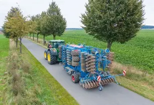
Krone and Lemken, through a joint project, have launched a design concept – Combined Powers – which is an autonomous ‘process unit’ consisting a drive unit and various implements

Spearhead Machinery offers the Starcut Blade System, with an aim to create a more cost-effective and environment-friendly approach towards the management of crop stubble residue and cover crops

Origin Digital, an agriculture technology company and Aspia Space, an advanced satellite imagery provider have announced ‘ClearSky’, a world-first service with an aim to revolutionise the way satellite imagery is used in precision agriculture by farmers around the world


According to Origin Digital, the new ‘ClearSky’ service, launching imminently in the UK, feeds radar data into a deep neural network to derive the view of a field that a satellite would see if there were no clouds blocking its camera.

This innovation means that farmers using ClearSky are guaranteed to receive an image every six days showing crop development, regardless of the weather. This is in contrast to traditional, weather-dependent imagery which can often have gaps of several weeks between cloud-free views.

Madhumita Mund Rao, head of data at Origin Digital, said, “This is a hugely exciting development because it adds the ingredient of dependable regularity that’s missing in traditional imagery services. This reliability will give UK farmers a substantial new advantage in sustainably optimising their yield and input use.”

“At any given time an average of 67% of the Earth is covered by clouds, so precision agriculture systems that rely on getting clear satellite imagery at the right time have historically struggled to deliver on their high potential value. ClearSky eliminates that struggle by guaranteeing the consistent regularity these systems need to deliver results, enabling farmers to fully optimise their fertiliser use for example and helping both their wallets and the planet,” she added.

Analysis by Origin Digital shows that the widely used European Space Agency ‘Sentinel 2’ satellites produced 13 clear images per UK farm on average in 2021. In contrast, the ClearSky technology developed by Aspia Space uses revolutionary techniques to produce more than 60 cloud-free images per year, which can be used alongside the clear images captured by Sentinel 2 and other providers.

Aspia Space co-founder Jim Geach said, “Aspia’s technology unlocks Earth observation imaging data and intelligence that would have otherwise been lost. ClearSky uses radar inputs, which penetrate cloud but are challenging to interpret, to derive imagery across the visible and short wave infrared spectrum. This means that even in the presence of 100% cloud cover, we can deliver regular, reliable, and consistent cloud-free images that are easily understood and can be analysed in exactly the same way as regular optical imagery.”

“ClearSky was developed using the idea that the way radio and microwaves behave when they hit surface features - such as crops - is correlated, albeit in a highly complex way, with the way that optical light waves interact with those same features. Using AI to unpick this correlation means that ClearSky can predict cloud-free imagery with no optical inputs without a loss of accuracy over long periods of time without clear optical images. That makes it a true game-changer,” he continued.

Following the UK launch, Origin Digital and Aspia Space are said to be deepening their collaboration to localise and export the benefits of ClearSky to farmers around the world, as well as developing further potential applications that bring innovative data insights to UK agriculture.


 The global agricultural machinery market  is expected to continue its positive phase after posting strong growth in 2020 and further increase in 2021

More Articles …